Showing posts with label Equity One. Show all posts

Monday, November 24, 2014

FOLLOW THE MONEY IN WESTBARD REDEVELOPMENT

Special Investigative Report

The pressure to transform the suburban Westbard area of Bethesda into an urban town center is not coming from residents. According to Montgomery County planner Marc DeOcampos, 85-90% of resident feedback during the week-long Westbard Sector Plan charrette was in favor of low-density development.

With those same residents panning the initial concept plan last week, and no clear incentives or perks to justify the negatives of urbanization on the Westbard area, where will any support for radical change come from in the Westbard Sector Plan process at the Planning Board and County Council levels?

Follow the money.

Developer Equity One, which owns all of the commercial properties along Westbard Avenue and Ridgefield Road, has partnered with local development firm EYA. EYA has donated many thousands of dollars to councilmembers. Here's a chart detailing checks the firm and its leaders have written to those members of the Montgomery County Council:

EYA (corporate)

2010
Nancy Floreen $250
Hans Riemer $500

2013
Hans Riemer $500

2014
Hans Riemer $500
Nancy Floreen $500

Bob Youngentob

George Leventhal $250
Nancy Floreen $1000
Hans Riemer $1100

LeRoy Eakin

Hans Riemer $500

Frank Connors

Hans Riemer $100

Aakash Thakkar 

Hans Riemer $743.12

The grand totals are $1750 for Councilmember Nancy Floreen (D-At-Large), $250 for Councilmember George Leventhal (D-At-Large), and a whopping $3,200 for Councilmember Hans Riemer (D-At-Large).

All 9 councilmembers will have the final say on the Westbard Sector Plan. If anyone keeps pushing for higher than 45' buildings in the plan, now that residents have made clear they are opposed, you'll know where it's coming from. Follow the money.

Thursday, November 20, 2014

SUBURBAN TO URBAN: WESTBARD PROPOSAL COULD ADD 4972 NEW RESIDENTS, 3758 CARS TO NEIGHBORHOOD

The future of the Westbard area of Bethesda is at a crossroads - will it remain a suburban residential area, with a commercial area that provides essential services to residents? Or will it become an urban area of concrete canyons, despite not being within walking distance of any Metro station? This is what ultimately the Montgomery County Council will decide. But right now, the planning process affords the opportunity for residents to be heard.

Residents have clearly spoken against the high-density proposal on the table now. As you can see in greater detail today in these images from the Plan Westbard web site, the plan as proposed would entirely change the character of the area from suburban to urban. 

This first image is virtually identical to what one would find in an urban town center near a Metro station, such as Bethesda Row or Rockville Town Square. The current sight lines to the forested tree canopy around the borders of the commercial area are all blocked by buildings. These 80' buildings will also impose themselves over the single-family homes of the Springfield neighborhood behind the Westwood Shopping Center, the Westbard Avenue homes on the other side of Ridgefield, and over the existing Kenwood Place condominiums.

If you are familiar with the Chevy Chase area, you will notice this second image is almost identical to what you would see while driving south into Friendship Heights - yet there is no Metro station to be found in the Westbard area.

There are a handful of non-conforming high-rises from an earlier time in the Westbard Sector Plan area. However, these are no longer allowed under current zoning, and placed far apart, they do not create the canyon effect clearly visible in the images immediately above. But the new structures combined with the existing towers would create a definitively urban character, out of context with the geographic location and low-density neighborhoods around it.

With schools and roads already jammed, it is unclear how this part of Bethesda could possibly handle the 4972 new residents and 3758 new cars that would be generated by 1927 new units. If anything, River Road would lose capacity under the new plan, with narrower lanes and new traffic signals. There's no guarantee of approval of a new elementary school on the current Little Falls Library site, as it is not large enough under current MCPS standards. And that doesn't even begin to address overcrowding at Pyle MS and Whitman.

Just the idea of 4972 more people, and 3758 new automobiles along two one-block strips boggles the mind. All of them will have to travel out of the Westbard area in the morning, as there is no new office space proposed for them to "live where they work," and no Metro within walking distance. And the "smart growth" folks say this scheme will reduce automobile use?

Wednesday, November 19, 2014

RESIDENTS REJECT WESTBARD CONCEPT SECTOR PLAN (PHOTOS)

The wraps came off the Westbard Concept Framework Plan last night at Westland Middle School, and residents quickly were asking them to be put back on again. "We just don't want it," might be the best summation of 90 minutes of resident feedback to Montgomery County planners. "This is the beginning, not the end," Westbard Sector Plan project manager John Marcolin said at the outset, as Phase 1 of a 2-year process came to a close.


Everything in the plan revealed Tuesday evening had mostly been seen last week, with the exception of a new 80' building shown for the area of the Westwood Shopping Center parking lot over by Westland. Previously, that site had been been proposed to have a height limit of 50', a significant difference. Given that Equity One's land area had only increased since Friday, with the deletion of a new elementary school site on the current Springhouse nursing home property, it was unclear what the developer had done over the weekend to suddenly gain 30' of bonus density. A second 80' tower would be allowed on Ridgefield Road where the Westwood Center II and Citgo currently stand, and all of River Road would be given a 75' height.

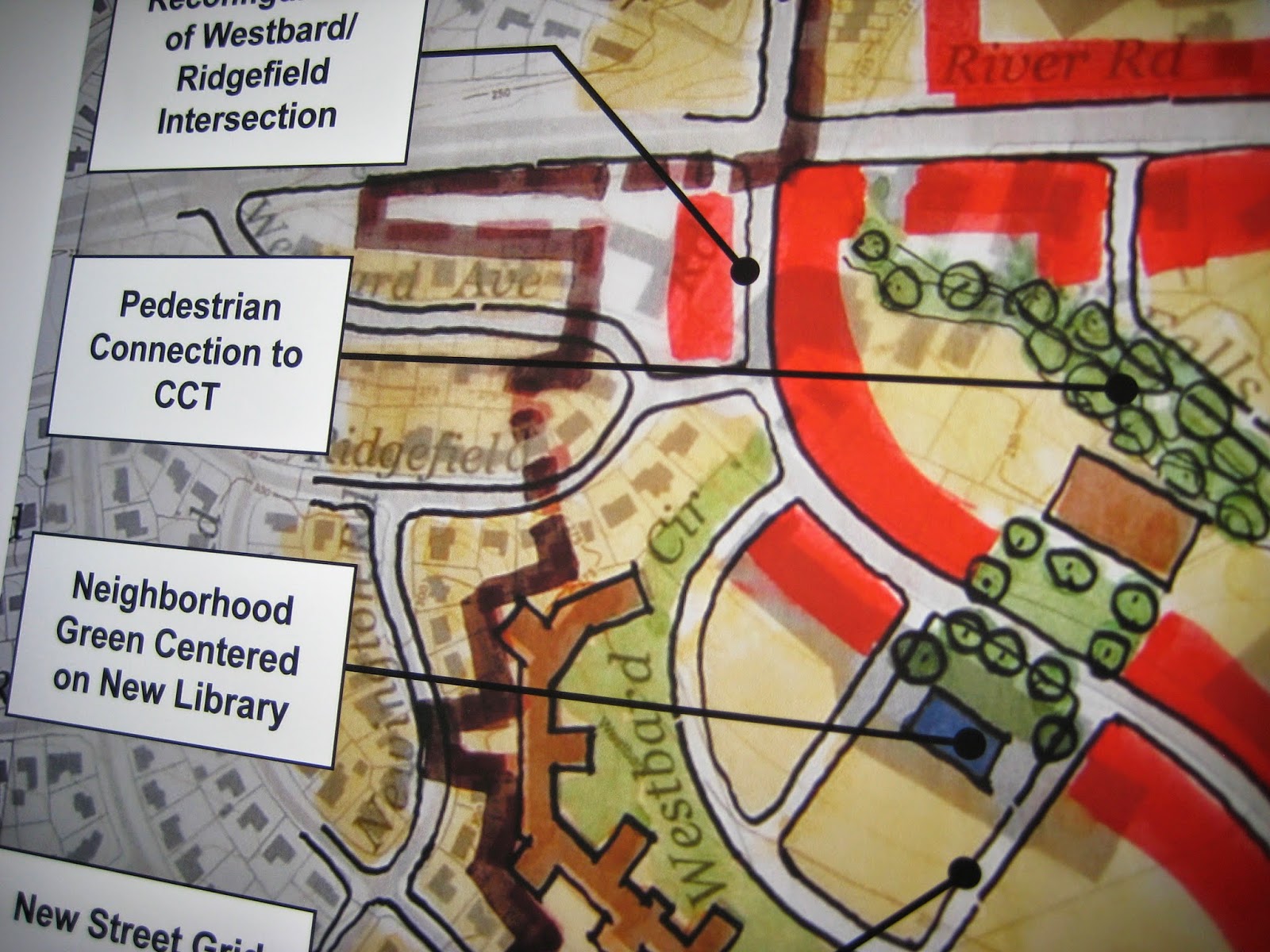
One connector road remains an option from Westbard Avenue to River Road along the Capital Crescent Trail, but an alternate map shows it cut-off from Westbard. That alternate map also shows an extension of Dorsey Lane to Little Falls Parkway. An extension of Butler Road to the parkway remains, as well. There will apparently be a parallel road alongside Westbard Circle at the border of Equity One's property with the Kenwood Place condos. Westland MS would still gain a new soccer field, but the impact on the forest area around the school was not discussed. Little Falls Library is shown moving into the "town square" at the current Westwood Shopping Center site, and its current location being used for a new elementary school.

With attendance estimated at 250 people, the 100 printed copies of the Concept Framework Plan quickly ran out, and dozens more metal chairs were wheeled in as the meeting got underway.
Westbard Avenue, or
Bethesda Row?

River Road, or
Friendship Heights?
Renderings of what Westbard Avenue and River Road would look like after full buildout of the plan drew gasps and grumbling from the audience. Essentially, they represented the worst nightmare of any resident or civic association who testified against the new zoning code rammed through by the Planning Board and Montgomery County Council, or the county's general shuffling toward urbanizing its suburbs. Simply unrecognizable, and a complete change in character from suburban to urban. It didn't help that the rendering of Westbard Avenue - using stock images, which of course (one would hope) won't be the architecture actually used - showed that same rounded off building you've seen in Rockville Town Square, Downtown Crown, and a host of other "town centers" in the area. In short, the images showed the "concrete canyon" many residents referred to last week during the many charrette meetings.

The estimates of new units were given at 1685-1927 at full buildout. That is less than the maximum plan (2529 units) shown last Thursday, but represents a stunning tripling of the current population and automobile count.
"That's just insane, and 
that's a nice word for it"
Out of 250 attendees, only one speaker supported the plan shown. Everyone else who rose to speak opposed the overall plan for a variety of reasons.

"This is my worst nightmare," said Sarah Morse, Executive Director of the Little Falls Watershed Alliance, which advocates for the stream branches that flow through the Westbard Sector Plan area. "I am squeezed out by high density everywhere." Noting the lack of green space, Morse asked, "Where are those people going to play? Where are the parks?"

A planner's laser pointing to the tiny postage stamp of a "town square" on the map elicited howls of laughter from the crowd. Along with an uncertain plan to create a new linear park along the beleaguered Willetts Branch Stream, that is it, as far as green space in the plan, which severely displeased residents last night. "I'm really so disappointed that this plan doesn't add any green space to speak of," said Mikel Moore, another LFWA board member.

Also missing from the map were gas stations, and several residents questioned that. Concerns of price gouging by any stations that would remain were cited, as has happened in downtown Bethesda. It is an issue that - as of this morning - no county official has taken seriously, even though it presents a public safety and emergency preparedness disaster as much as an economic one. When a weather or - God forbid - terror event strikes, where would people fill their gas tanks? With the map showing no gas stations left at all, the plan seems to encourage more driving, not less. "It is a concern," said Senior Urban Designer Paul Mortenson of Bethesda's vanishing gas stations.

Residents advocated for other services necessary to the community, from auto repairs to the Westwood Pet Center. "What this area provides is a service to the community," Norman Knopf told planners. "We want to keep that service." Another resident said, "we love the stores that are there now."

Schools were another sticking point, and planners did not have definitive answers about how MCPS would accommodate new students at all three levels in the already-overcrowded Whitman cluster. Even the plan to build a new elementary school on the library site is uncertain, as the land area is not large enough to meet current MCPS standards for an elementary school, much less ample enough to provide the outdoor facilities needed for recreation and other practical concerns. The spectre of redistricting had one mother wondering if the elementary school her daughter was looking forward to attending would still be available when the time comes.

Traffic was just about as much on residents' minds. With the density proposed, one resident predicted the plan couldn't "possibly result in anything but horrible traffic."

Since the impact on schools and roads is driven entirely by density, the urban growth shown came under sharp fire from residents. "What you're doing by adding density is creating a wasteland" of automobile congestion, argued one.
"Honestly, that's
ridiculous."
Residents were clear from the beginning that they wanted low-rise buildings. One last night referred to Poundbury, England, a new urbanist planned community with lower scale buildings. "I frankly love Poundbury," Mortenson replied. "It's a gorgeous town."

Many were upset by the perception that the entire process is being driven by developers. "I hope you're keeping in mind your constituency here," one resident warned. "Your constituency is us." "I feel defrauded," said another. "I expect more from Montgomery County than this."

In the most heated exchange of the evening, a resident of Springfield - a neighborhood directly behind the Equity One site - challenged planners to identify the specific problems in the Westbard area's zoning that the Concept Plan would correct. "You're not identifying any problems with the current zoning," which would cap heights at 45'. "What are they?" he demanded.

"We haven't identified all of them," Mortenson responded. "Surface parking is not ideal," he noted.

"We like it like it is!" shouted a resident from the crowd.

"I don't have an answer to the question," Mortenson said.

"Stop lying to us!" bellowed one audience member.

In a more mild-mannered wrap-up to the public comments, a gentleman from Nebraska said the problem with the process was that it was placing design and land use before public facilities. Since so many problems with the plan relate to lack of sufficient infrastructure capacity, he urged planners to "put all of this on hold," until the county can articulate its solutions to providing adequate public facilities. He cited the Doctrine of Comprehensive Planning as the model to follow.

How should planners proceed? Here are my thoughts:

First, I think the Charrette process was a valuable one. I grew up here, and even I learned some new things about the neighborhood over the last nine days. With planners' help, we've identified a lot of the problems and concerns, even if we don't have the solutions yet.

Second, there is one great proposal in the plan - the daylighting of Willetts Branch Stream, and the construction of a linear park and trail alongside it. I would be fantastic to see that happen. It might be nice to have a brand-new library, although I happen to like the current one. It would also be unfortunate to lose a forested library site, and end up with a bait-and-switch apartment building there instead of an elementary school.

But there's no reason that planners cannot salvage a workable plan from all of the work they and we  put in last week.

So keep the Willetts Branch Plan. Change the proposed zoning back to the current 45' maximum height on Westbard and River Road. Frankly, I'm not convinced we need 45' on all of that area myself. There's big money in shopping centers, especially in 20816.

We've been told that development needs to be greater in scale to be profitable. But this past weekend, a beautiful new shopping center opened in Upper Marlboro. The Osborne Shopping Center was closed after 20 years at 7583 Crain Highway, and replaced by...a new shopping center. No apartments. No townhouses. No residential component whatsoever. Just a fabulous new strip mall shopping center with plenty of free surface parking, and a brand new Safeway store anchoring it. The Osborne Shopping Center pretty much shoots down the argument that Equity One can't simply give us a better shopping center. Equity One would still have plenty of room to develop across the street at 45'.

The 80' heights of two buildings proposed are incompatible with the nearby single-family homes, as are the 75' heights on River for Kenwood. These buildings will impose themselves on backyards of people who have invested just as much in their properties as the developers. And with no Metro station at Westbard, the heights and density proposed are simply creating more automobile traffic.

Planners should make an explicit text and map recommendation to retain the gas stations along River Road, and at least one on Westbard. Period. With more cars being added, we have to have gas stations to fill them up.

Regarding schools, the plan should not be approved until MCPS has made clear exactly what capacity improvements or new school construction it will provide to meet the number of students generated by the new units. Can the library site actually work for a school? We need to know that, and what they'll do at the middle and high school levels, as well. Is redistricting ahead? Tell us the truth now, not later.

Planners, and Planning Director Gwen Wright, have acknowledged that Westbard is not a transit station community. The plan needs to better reflect that, as well. With no new office space proposed, virtually all new residents will be heading into the District each day for work. New units will require new capacity on River Road and Massachusetts Avenue. As of right now, no such project has been proposed. We need to hear specifics from the State Highway Administration as to what can be done. You could widen River Road, but that would require taking front lawns east of Little Falls Parkway, and the road narrows in DC, anyway. So what is the answer? Maybe it's that this area is currently built out, and its roads and schools can't handle major new development.

I don't think residents are asking as much of the Westbard area as planners seem to be. No one considers the commercial strips along River and Westbard to be grand boulevards. They are simply service areas where one can fill the gas tank, get a quick meal from the drive-thru at McDonald's, buy some pet food or pick up a prescription. Could pedestrian and bicycle access be made safer? Sure. But there's no reason that can't happen at 45' height. This is perhaps the most in-demand area of the county, with Whitman schools and right outside the DC line. If apartments are built at 45', they will fill up quickly. They will probably still be too great in number for our roads and schools to absorb, but what is currently proposed is far worse.

The suburbs should remain suburban, basic residential services must remain, and the plan should put quality of life ahead of all other priorities.

Does that require putting the concerns of residents above the profits of developers who consider the neighborhood their personal Monopoly board? Absolutely.

Monday, November 17, 2014

WHAT WOULD THE IDEAL LITTLE FALLS LIBRARY BE LIKE IN WESTBARD REVELOPMENT?

Along with plans for daylighting Willetts Branch Stream and a potential new elementary school, the idea of relocating Little Falls Library to the Equity One redevelopment on Westbard Avenue is one of several intriguing ideas floated in the early Westbard Sector Plan process. I happen to like the current library, its architecture - and large side window, and forested setting. It is perhaps the ideal suburban library. Despite my nostalgia, I would begrudgingly admit it is growing outdated.

One of several public meetings held last Friday sought to get feedback from Montgomery County Public Libraries and nearby residents on the feasibility of relocating the library, and what features the ideal library would have.
Rita Gale (foreground) of MCPL
discussed what the ideal new
Little Falls Library would be

Rita Gale, Public Service Administrator for Facilities and Capital Projects for MCPL, discussed potential floorplans and designs with planners Marc DeOcampo and John Marcolin. Gale said MCPL is on board for the idea of libraries as anchors of public squares, with the Rockville Memorial Library being the most notable existing example. How would a potential land swap and construction of the new facility occur? It would likely be a public-private partnership between MCPL, Equity One and Montgomery County Public Schools, should the current library site become a school site.

Gale explained that the library system utilizes 3 year strategic plans. She mentioned that MCPL recently shifted from complete renovations of libraries every 20-30 years to mini-renovations every 7 years. The reason for the shift was the inability to keep up with technological changes on a 20-year calendar. If the relocation were to go forward, the existing library would remain in operation until the new building was ready to move into.

What would that new building be like, ideally? 23,000 square feet on a single floor, said Gale. Why a single floor? Staffing one floor is far less expensive than multiple floors. Meeting space would preferably be on a separate level, as that does not require the same level of monitoring by employees, Gale said. The existing Little Falls Library is far smaller at 10,000 SF, while the Rockville Library is 63,000 SF by comparison. Having the library at street level would also be important, as is free parking for patrons. I have to say that paid parking at the new Equity One development on Westbard would be a non-starter.

In regards to the second options planners have outlined - adding an addition to the existing library - Gale said that would require removal of several mature trees, and "generally taking down trees is not something that's appealing to folks. Of course, if the site becomes a school, those trees would come down anyway. Neither clearcutting sounds like a good idea at a corner of Bethesda known for its forested surroundings.

Residents who have spoken to the potential library relocation seem to be cautiously favorable in their opinion about it. One detractor at the meeting said a library would be a terrible choice for what is being touted as a vibrant public space. He argued the new library would be a "dead space in the evening. Leave the library where it is. [Relocating it] makes no sense to me whatsoever." He noted that a similar library upcounty, which has residential units facing it, has become a hangout for drug dealers after hours, and a magnet for crime in general. DeCampo said Equity One would likely take steps to secure the site, particularly with residents living in close proximity to it.

I thought the man did have a valid point, as - assuming the library operates on the typically-limited MCPL hours - the space around it could become a dead zone after 6:00 PM. Banks are another notorious vibrancy killer in urban settings. It would seem that other more active tenants would have to be located close to the library in order to prevent that from happening. Having said that, I don't think anyone expects the Equity One "town center" to be a noisy city that never sleeps. This is a bedroom community in the suburbs, not a true urban area, and should tone down the volume at night anyway.

The other thing those comments brought to mind, is the need to recognize that public areas - of which there are currently none on Westbard Avenue - need policing, as well as upkeep such as that which Bethesda Urban Partnership provides downtown. That should be considered during the design phase, as security costs money, whether it is public or private.

Thursday, November 13, 2014

CROWN ST. BYPASS, HEIGHT, DENSITY REMAIN STICKING POINTS IN WESTBARD SECTOR PLAN OPTIONS (PHOTOS)

Day 2 of the Westbard Sector Plan charette was even busier than the first, with meetings sometimes going on simultaneously in the Montgomery County Planning Department's temporary space in the Westwood Center II shopping center. A fascinating discussion of history and environmental issues started the day with the Sunrise Session for business owners.

Some industrial business owners who own their land are open to selling for the right price. Others, like Bonds' Citgo service station on Westbard Avenue, would like to stay if allowed by landowner Equity One. From all that was discussed, there are many environmental issues within the sector, ranging from serious to scary, and could deter construction of residential housing on those sites without very costly cleanup. Did you know that the owner of a pesticide business on Butler Road was a Navy Cross recipient, a pilot in the Battle of Midway, and a P.O.W. in the Bataan Death March? What a story!
Planner Fred Boyd talks with the
Springfield Civic Association
The Springfield Civic Association's top concerns were schools, traffic (particularly cut-through traffic), and zoning/density. SCA President Phyllis Edelman said "current transit is insufficient" in the Westbard area. She said the SCA opposes connecting a current cul-de-sac on Jordan Road into the future Westbard "town center," because it would be "opening a can of worms." The association, which represents the neighborhood directly behind the Westwood Shopping Center, supports the plan to daylight Willets Branch Stream. SCA Zoning Chair Pete Salinger said of the future redevelopment of the Westwood Shopping Center that "most of us, almost all of us, want to retain that local flavor, the community feel that we've got here."
Brookdale residents tell planners
Boyd and Marc DeOcampo their
top concerns 
Brookdale, a neighborhood of single-family homes near River Road and Western Avenue, stressed schools, the need for more sports facilities, protection for tree canopy, cycling facilities, and protection of pedestrians walking to school and to the Little Falls pool. They also want to retain the local services in the shopping centers and industrial areas, such as auto repair, gas stations, and pet stores. Planner Marc DeOcampo said that such industrial uses are key to the continued success of neighborhoods inside the Beltway.
This map of possible new roads
to address cut-through traffic
concerns was not pleasing to
residents closest to their
proposed locations
The session on transportation was the most tense of the day, as Westbard Mews residents came out to condemn the proposed Crown Street bypass from Westbard to River Road next to their homes. Westbard Mews President Dick Mathias said he was "shocked that I hear what I feel is a strong bias by planning staff to build this new road, 20 to 40 to 50 feet in front of houses and damage" their values. "This came up for the first time Monday night," he continued. "We'd never heard of it. [You] give us six days to mobilize opposition...it's a screwy way to develop."

A current Crown Street resident said, "You would destroy our community and the value of our homes in one fell swoop, what for us is an oasis of calm."

By Wednesday night, planners had offered a new alignment that would run the bypass off Westbard through the Park Bethesda property as an option.
We're not done yet! It's off
to Whitman HS for the
presentation of planners'
work since Monday night
Speaking of Wednesday night, planners unveiled 3 alternative designs for the new Sector Plan, and took feedback from a not-so-happy audience. Heights in all three were higher than many residents had asked for on Monday. "We're slipping towards downtown Bethesda," one resident said, and felt that planners "did not include the feedback given by residents Monday night."

Planner Paul Mortenson responded that "we didn't feel that was fair to those [land]owners."

"I think it's a little bit disingenuous to say it's not fair," the resident rebutted, arguing that Equity One had said it could make a profit even without changing anything about the existing retail on Westbard.

Mortenson said planners are encouraging developers to choose structured, not surface parking. One resident said she often shops alone, and that surface parking "works for me. I feel safe. Parking garages are a nightmare." Equity One proposed an underground garage on Monday.

Residents did praise provisions in the plan for a new elementary school, buffering for Kenwood Place, and daylighting of the Willets Branch Stream. Each of the 3 plans had different road alignments and components, and locations for a new elementary school. Residents were split in opinion on those. There was also support to retain one of the Citgo stations on Westbard Avenue (including from me), as an essential service to the community.

I have to say that the planners did come up with several innovative ideas to deal with traffic, even if they are controversial, and the potential new school and Little Falls Library sound promising. The transformation of the stream into a new linear park would be fantastic. Whether the schools and roads can handle the density permitted is unclear. The heights being talked about for the Park Bethesda site are surprisingly high, as well. I hope we'll hear more from the State Highway Administration on how road capacity might be expanded on River Road, and that concerns about the environment and lost history of the African-American community there can be addressed in the plan process.

Planners will now take feedback on the 3 versions, and try to create a final composite for presentation to the community and the Planning Board. You can examine them below:
Option 1
(See close-ups on
details below)

Area of today's Westwood
Shopping Center and
Westbard Avenue


Option 2


Option 3


Tuesday, November 11, 2014

NEW WESTBARD SECTOR PLAN IDEAS: UNDERGROUND PARKING, NEW ROAD, NEW TRAIL, NEW LITTLE FALLS LIBRARY? (PHOTOS)

Day 1 of the week-long Charette process for the Westbard Sector Plan was an eventful one Monday, with several new ideas coming to the fore. Among the most intriguing - and in some cases, controversial - were proposals for a new road between Westbard Avenue and River Road, a new trail alongside Willets Branch Stream, and a new site for Little Falls Library. The day concluded with a mapping session with all stakeholders at Walt Whitman High School. Here's a recap:
Project head John Marcolin
leads the 10:00 AM
walking tour of the Westbard
Sector area

Environmental planner
Marco Fuster discusses
options for restoring
Willets Branch Stream
(flowing below the sidewalk
area pictured along River Road)

Near the former WDCA 20
TV station building, with one
segment of a potential new
road right-of-way visible
alongside the Capital Crescent
Trail at left-of-center

Monday morning began with a meeting between Montgomery County Planning staff and representatives of the Kenwood Place condos. Between that meeting, and later comments by condo owners at the Whitman meeting, several themes and concerns emerged for Kenwood Place residents, whose property directly borders the Westwood Shopping Center. Many Kenwood Place residents would like their property to become a gated community, sealed off from public access - possibly literally, by a fence. They would prefer that heights of residential buildings on the shopping center site, and nearby, be capped at 40', and that adjacent properties be substantially set-back from their site. Retail and restaurants should serve local residents, with no national chains, in their opinion.

Two main points of contention regarding Kenwood Place going forward are whether or not Westbard Circle will be sealed off to the public, and a new public road on Equity One's Westwood Shopping Center property be built parallel to it; and a possible pedestrian/vehicle access point into the future Equity One development via an existing cul-de-sac on Jordan Road. County planners and Equity One seem to concur that a single road would be preferable between the two developments, for stormwater management reasons primarily for the latter. There seem to be mixed opinions on the Jordan cut-through at Kenwood Place. One point on their "list" was a concern about cut-through traffic via Jordan Road. But at least one Kenwood Place resident later felt that such a Jordan access point could assist in achieving the gated community concept. Such a connection into Jordan Road was strongly denounced by a resident who lives in that cul-de-sac, who noted that 16 children live nearby and play in that space, and that neighbors host gatherings there, such as a Halloween bonfire. Concerns about safety and lighting of such a connection were also raised.
Walking tour continues
on Westbard Avenue
Next up was a walking tour of the Westbard Sector. At the start, Project Manager John Marcolin wanted to make clear that the Planning Department was paying market rate for its temporary space in Westwood Center II, where most of the meetings were held, to avoid any sense that it was being favored or influenced by landlord Equity One. Marcolin cited the River Road McDonald's property as the only one to execute the boulevard concept and frontage envisioned in the 1982 Westbard Sector Plan. Some of the current flaws in streetscape design and stormwater management were highlighted, and there was even some background on Westwood Tower from the Housing Opportunities Commission.
Planners gave a 10th floor
overview of a proposed new
road that would run
behind the Park Bethesda
Without a doubt, the biggest news of the day was a potential new road connecting Westbard Avenue to River Road. Using a County-owned right-of-way that runs alongside the Capital Crescent Trail, and a second County R.O.W. along Crown Street, planners suggested that a new road could be constructed to run from the current end of Crown Street to the trail bridge by McDonald's at River Road. A traffic signal would be installed there, and cars would be able to continue across into a new road in the Landy Lane/Washington Episcopal School area, ultimately reaching a signaled intersection on Little Falls Parkway. Current landowners such as EuroMotorcars Volvo would have to contribute small parcels to facilitate construction of the road, which planners believe could divert cut-through traffic away from a slowed-down "Main Street" on Equity One's stretch of Westbard Avenue. Planner Marc DeOcampo said that WES could be urged to accept the new roadway when its residential development plan comes back before the Planning Board.
Some property would have
to be acquired to complete
the new road

Sketch map of proposed
Westbard bypass via
Crown Street, and
crossing River Road
into Washington Episcopal
School area to Little Falls Parkway

Impact of new road on
EuroMotorcars property
Initially concerned about the implications for their site, representatives for EuroMotorcars eventually warmed to the idea, as it would provide exposure for their auto repair facility that is currently hidden from busy River Road.
EuroMotorcars discusses
its River Road site with
planner Marc DeOcampo
But it will be a hard sell for Westbard Mews, and some residents of that townhome community were not pleased by the news. Kenwood residents at the charette seemed to favor it as one of several mechanisms to reduce the cut-through traffic that plagues that neighborhood. What seems like a fresh and innovative solution could ultimately divide individual communities who are otherwise united in opposition to urban-style density and massing at Westbard. I have to commend planners for coming up with this concept, as I was not aware that this was even an option. I think more feedback of residents directly impacted by it will be needed before green-lighting this, however. I suspect there will be a lot of outrage about the idea in Westbard Mews, and understandably so. My first reaction was, great idea. The next thing I thought was that Westbard Mews residents are going to go into orbit when they hear about this.
Willets Branch Stream

One proposal would restore
the stream to its natural state,
and add a path alongside
Less controversial, but - in my opinion - positive, was a proposal to daylight the channelized and tunneled sections of Willets Branch Stream and add a trail alongside it. This could potentially create a narrow park through the current industrial area and, done the right way, could be an asset similar to Carroll Creek in downtown Frederick, if not as large in scale. Such a linear park could also facilitate small park areas along it, where plaques or memorials to the history of the Georgetown Branch Railroad, or the lost historic African-American community along River Road could be placed.

Also new was planners' proposal to move Little Falls Library from its current site into the "town center" of Equity One's property on Westbard Avenue. Rockville Town Square's library configuration was cited as an example, although I've heard mixed opinions from commercial real estate folks and Rockville residents about the success of placing the Rockville Library there. It's worth exploring, but it's unclear if Equity One would be willing to delete that much potential retail/residential square footage for a library. Equity One's Michael Berfield did seem willing to consider that and other requests for public amenities on Monday.
Equity One makes its
presentation to planners
Monday
Berfield and Equity One's architect fleshed out a few more details of their potential redevelopment concept yesterday. They reaffirmed their previously-stated goal of creating a "Main Street" for retail along Westbard Avenue. Townhomes are the proposed use for the Manor Care Springhouse at Westwood (apparently now vacant) site and for the parts of the Westwood Shopping Center that border existing residential uses. Berfield proposed 2-story retail along the Westbard Avenue side of the property, potentially placing the site's grocery store on the second floor, while leaving smaller street-level spaces for diverse and "quirky" retail and dining. He said Equity One is "all about the retail," but stressed that there would be no retail tenants that would make Westbard a regional destination. Nothing here would draw people from far distances, or be different from what you would already find in nearby communities in the region, Berfield said. Of course, taken to the extreme, that would seem to work against creating a distinctive sense of place for the Westbard area. I don't think residents would want a cookie-cutter mix of "the salad place," the Chipotle, and "the cupcake shop" one finds at so many town centers. Equally or more important, the architecture needs to be unique enough that one only identifies it with Westbard.

Parking was discussed, and Berfield's suggestion for now is that parking will be primarily in a one-level, underground garage. I wouldn't want to totally dismiss that before seeing what else the eventual plan has to offer, but I personally don't feel garage parking is appropriate for the Westbard area. For the same reason that structures should not have a "wall" effect that blocks existing sight lines to the forested character of the surrounding neighborhoods, I don't think concrete surroundings are necessarily appropriate for a suburban community.

There is also the potential that the demolition of Westwood Center II, which sounded inevitable from Equity One's presentation Monday, would allow Ridgefield Road to be shifted onto that site, and away from its existing intersection at Westbard Avenue. This would ostensibly divert outside traffic trying to reach the Equity One development away from the Springfield neighborhood on the 2nd block of Ridgefield and upward. One would hope it would also facilitate more stream buffer around Willets Branch there, and a better turning scenario for tractor trailers coming off of River Road.

While promising "low-rise" multifamily housing on parts of the current Westwood Shopping Center site, Berfield pledged to "go taller" on the other side of Westbard, citing examples of 10-15 story projects elsewhere.

At no point in the day did I ever hear about office space. In order to achieve "smart growth," it is necessary to have workplaces near residential housing. Is there a plan to add office space to reduce the number of commuters generated by the new residential growth here?
Kenwood Civic Association
meeting with planners Monday
Kenwood itself was adamant that building heights along River Road be capped, with no exceptions for amenities or parcel collection.

Ultimately, most groups at the nighttime session repeatedly said that they couldn't find sample photos in the sets provided that showed the lower density and height they preferred. Comments strongly reflected a word cloud Marcolin displayed at the outset. The biggest words were SCHOOLS, TRAFFIC, and RIVER ROAD. Long-term MCPS planner Bruce Crispell made an appearance to take questions from frustrated parents of children in already-overcrowed schools.
Using markers, trace paper, maps
and tape, stakeholders tried
to reach a consensus at tables
throughout the room last night

Participants could choose from
these height and density options

Getting set to start

My group's map when nearly
finished

Concerned parent asks MCPS
long-term planner Bruce Crispell
about overcrowding in the
Wood Acres/Pyle/Whitman cluster
I was at a table with a smart group of residents who were able to lay out a lot of what the community wants in principle. I don't know if planners will be able to interpret everything we pasted on there. For example, a photo of Bethesda Lane was posted to show the concept of an iconic public space, rather than as a marker for building heights on Westbard. I pasted a sample photo of modern, single-family homes on the spot where the Manor Care is now. That would seem to be more consistent with the adjoining single-family homes, while remaining profitable (lots seem to be far smaller today) and respecting the lack of space in existing schools. I also suggested keeping one full-serve Citgo station on Westbard to serve the community, particularly senior citizens who regularly use that option. One other important point would be that the type of restaurant attracted can often be determined by the square footage of the space. So to get a sit-down restaurant (as opposed to a carry out), you need a certain minimum square footage to attract that type of tenant. I hope that Equity One will design its spaces accordingly, as there are no sit-down, family restaurants in the Westbard area currently.
At the charette, this was the
closest example I could
find for an appropriate height
for multi-family housing
on Westbard Avenue
Stay tuned for more on the Westbard Sector Plan this week.